
Difficulty Ratings: Regular Hike & Related Events
The following is a general description of the hike ratings as shown in the Hike Schedule. While some hikes may not fit clearly into one of these categories, these ratings should help you to select hikes that match your interests and capabilities.
Remember that the most difficult section of a trip determines the overall trip difficulty.
Easy (E):
Generally less than 10 km in length with elevation gains of less than 300 M and no steep slopes. Well-maintained trails with few if any hazards to footing. A relaxed pace with plenty of opportunities to stop for rests, observe surroundings, and study the flora and fauna, or simply to socialize. This section also includes city walks that are mostly considered easy, although some may be as long as 10 km and may involve some climbing (e.g., Nose Hill Park). Prepare as you would for other hikes, bringing your lunch and adequate water.
Moderate (M):
Typically about 10-15 km in length and/or 300-500 M elevation gain. May have the odd steep sections and rough trail conditions (e.g., exposed roots, rocks or even occasional loose scree). A steady pace is normally maintained with fewer stops than on the easy hikes. Some endurance is required.
Difficult (D):
Typically 15-25 km in length and/or 500-1000 M elevation gain. Likely to encounter steep sections as well as difficult footing (e.g., loose scree). A brisk pace is required and hikers must have both strength and endurance for the distance and the elevation.
Extra Difficult (XD):
Either more than 25 km in length requiring superior stamina, or in excess of 1000 M of elevation gain requiring strong legs, or both. On the major climbs very steep sections are almost certain to be encountered with loose rocks and scree and other hazards (e.g., scrambling over exposed faces or following narrow exposed ridges). Unpredictable weather can greatly increase the hazards.
Anyone afraid of exposed conditions (e.g., narrow ledges or ridges and scrambling over exposed faces) or uncertain of his/her strength and stamina under the most demanding of conditions, should not attempt extra difficult hikes.
Snowshoe Events: Special Ratings
Snowshoe events are rated on the grid below according to distance and elevation gain. Trip coordinators should also consider:
- Whether or not breaking trail is required
- The avalanche conditions on the day
- Temperature
- Pace: relaxed, steady, or brisk
- The most difficult section of the trip, which should determine the overall trip difficulty.
Trips may be modified or cancelled if the trip coordinator believes the conditions warrant it.
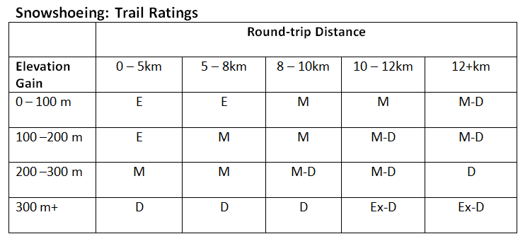
Key:
E = Easy
M = Moderate
M-D= Moderate to difficult
D = Difficult
Ex-D = Extra-difficult
Please note: Short steep snowshoe trips may be more difficult that a longer trip with the same elevation gain. Trips rated D or Ex-D may require the use of climbing snowshoes.
Examples:
E = Hogarth Lakes
M = Warspite Lake
M-D = Chester Lake / Rummel Lake
D = Rummel Pass / Prairie Mountain
Ex-D = Smuts Pass / Buller Pass
Cross-Country Skiing Ratings
Rating Descriptions according to Chic Scott’s book, “Ski Trails in The Canadian Rockies”:
Nordic skiing: “Takes place on well-maintained trails, which are usually packed and often trackset”
Ski touring: “Takes you into the backcountry, usually below treeline but sometimes up into the subalpine. Trail breaking is often required”
Ski mountaineering: “Takes you into the alpine zone, high above treeline. Glacier travel is usually involved and a more advanced level of skills is required. One should have solid skiing abilities”
Easy: “These trails are normally suitable for a novice or inexperienced skier (within the parameters of the above trail designations). Route finding is not difficult and there are few hills.”
Intermediate: “These trails are more challenging and will often have steep hills which require more advanced skiing abilities.”
Advanced: “These trails may have extensive sections requiring advanced skiing skills and may also present serious route finding challenges.”
For more detailed ratings according to individual trails (e.g. Boom Lake, Skogan Pass, etc.), please refer to Chic Scott’s book itself: Ski Trails in The Canadian Rockies.
Bicycling Trip Ratings
We encourage all coordinators to quote trail ratings provided by either book authors and/or research about the trail to decide on the difficulty rating for your cycle event. Take into account distance, hilliness, amount of motor vehicle traffic, highway shoulder width, road/trail surface, normal wind flow etc.