April 2021 CORE Newsletter
Executive News
Next Members Monthly Meeting will be Tuesday, May 25,2021 at 7 pm by Zoom.
The May 25, 2021 meeting will be CORE’s Annual General Meeting. More Details will be coming. Watch for CORE email calendar notifications.
Member Volunteer’s for CORE Executive Positions for 2021 – 2022 year
CORE executive is looking for members to volunteer for 2021 – 2022 executive positions. The Positions are:
- Chair
- Co-Chair
- Secretary
- Treasurer
- Membership Coordinator
- Executive Trip coordinator
- Communications Coordinator
- Presentations Coordinator
- Webmaster
- Member-at-Large
More information on these positions will be emailed to you shortly. Please consider helping your club by volunteering for one of these positions. If you have any questions regarding a position or you would like to volunteer for one of these positions please email the current CORE executive at mailbox@corehike.org .
Hiking Apps – Something for Everyone
Ever wondered when technology would reach the backcountry? The good news: it already has. There are plenty of apps and hiking companions that offer navigation and guidance without the need to be connected to WiFi. Click here for a comprehensive guide.
To All CORE Outdoor Event Participants:
Social (Physical) Distancing for COVID 19
The club executive recently met (virtually of course) and talked about the current COVID-19 situation in Alberta. The third wave we are in now has been far worse than the first or second wave, and more seriously. The highly contagious U.K. and South Africa variants are in Alberta. These variants now make up 45% to 50% of all covid-19 cases in Alberta.
All of this makes us now believe it would be prudent to put a stronger emphasis on physical distancing for the next few months at least. We are therefore requesting all trip participants to make a more concerted and conscious effort to physical distance from others, while hiking, winter hiking, urban walking, biking, and other events. (Consider wearing a mask in the parking lots before – and after – the trips).
Thank you for helping us to keep our club members safe.
The CORE Executive.
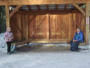
CORE’s new meeting Facility is Bow Waters Canoe Club
Bow Waters Canoe Club is located just off Deerfoot Trail and 17th Ave SE. Address of the facility is 1975 – 26th Street SE.

Bow Waters Canoe Club map
Directions:
From East or Westbound 17th Ave SE (see map below states 1A, which is 17th Ave)
Turn South on 26th Street SE (there is a set of lights at this intersection),
BWCC Road turnoff
Ensure you are in the right hand lane and immediately turn right where the City of Calgary Utilities/Electrical station is (it is a small black building with LED lights on it, indicated by the red arrow below).
Follow the road down to the parking lot. Take the stairs down to the club house building.
CORE, ACTIVITIES/EVENTS DURING THE COVID-19 PANDEMIC:
CORE executive has put in place guidelines and recommendations for trip coordinators, and COVID-19 guidelines for keeping members safe, when participating in CORE activities/events. CORE executive would like to thank all CORE members that put on hikes, bike rides, urban walk’s, etc. for their club members during this unprecedented time.
Spring is now with us. More activities are planned for the coming months. Continue to watch your emails and CORE calendar for activities/events.
Members are encouraged to read the Guidelines “Hiking with CORE in the Time of COVID-19 pandemic.”
If the province of Alberta mandates different requirements, the organization may have to make appropriate changes. If the situation changes a newsletter with the updated information will be sent to the members.
CORE Photo Album
All CORE members participating in CORE activities are welcome and encouraged to post photos taken on your outings in the CORE website Photo Albums. There are Photo Management instructions on the CORE Guides web page. If you have any trouble uploading your photos, please ask the event coordinator or other experienced CORE member. Some guidelines when posting photos:
- Post just the highlights of the event
- No parking lot photos. We should not identify members vehicles
- Do not post unflattering pictures of other members
- If you mention a person’s name, use only the person’s first name
Contacting your Executive
CORE has a couple of different purpose-oriented email addresses through which you can contact various executive members. If you have a general question’s about the club, for instance upcoming presenters planned, event, etc, please email us at mailbox@corehike.org. If it is a question about membership or joining the club, please direct your query to membership@corehike.org.
Remember that our CORE Executive members are volunteers who also have day jobs and a life outside of CORE, so please be patient if it takes a few days to respond to your queries.
ACTIVITY SCOREBOARD
Highlights of Activities/Events
Here are a few highlights from the CORE calendar of hikes from March 15 to April 15, 2021. Please visit the CORE photo albums for more pictures from recent and past activities.
…………………………………………………………………………………………

March 21 2021 Rawson Lake Winter Hike
…………………………………………………………………………………………

March 26 2021 Ha Ling Peak Winter Hike
…………………………………………………………………………………………

March 27 2021 Inglewood Harvie Passage Pearce Estates Urban Hike
……………………………………………………………………………………………………..

April 2 2021 Sandy McNabb Hill Loop Hike
……………………………………………………………………………………………………..

April 11 2021 Spray River Loop Hike
…………………………………………………………………………………………………….

April 13 2021 Spray River Loop A Repeat Hike
………………………………………………………………………………………………………
April 15 2021 MCConnell Point aka Engagement Mtn Hike
……………………………………………………………………………………………………….
News and Notes
Get your Bicycles tuned up!!!
Bow Valley Parkway to be Closed to Vehicle Traffic Summer of 2021

CORE members cycle trip
After a successful summer last year, Parks Canada has announced, the closure on Hwy #1A will remain closed to public vehicles throughout the summer of 2021. Daniella Rubeling, Parks Canada Visitor Manager, stated “the closure last summer proved to be so popular, they are doing it again for the summer of 2021. Parks Canada received a great deal of positive feedback from cyclists who enjoyed the vehicle-reduced experiences on the Bow Valley Parkway last summer. Cyclists found it to be safe and enjoyable and expressed an interest in seeing this highway closed in the future for cycle traffic only.”
Vehicles will be restricted from the east end of the Bow Valley Parkway, where it meets Hwy #1 to the junction with Hwy #93 south.
September 2020 CPAWS and Parks Canada tracked the public’s opinions about the highway closure. CPAWS survey had 3120 respondents who used the road and people that were turned away in vehicles. “Close to 90% of respondents were extremely satisfied with their cycling experience and respondents were in strong agreement that their recreational experience was better because of the closure should continue in some form beyond 2020” stated Sarah Elmeligi who serves as the national parks program co-ordinator for CPAWS.
Rubeling believes the success of the Bow Valley Parkway closure and the joy and fun that people have had cycling this route demonstrates that people are open to a lot more creative options than parks had previously assumed.
Remember Bow Valley Parkway is closed to vehicles, cyclists and hikers from March 1, 2020 to June 25, 2021 from 8pm to 8am for its seasonal closure. This seasonal closure is to give wildlife space during the spring, as this is their critical time of the year.
Lake Minnewanka Road closed to Vehicle traffic for Cycling

CORE members cycle trip
Parks Canada is testing this spring some weekday cycling. And one of these is a Minnewanka Loop Road in Banff National Park. The Lake Minnewanka Loop Road will now be closed to vehicles on Mondays to Thursdays from May 1 to 20, 2021.
Rubleing states, “Its about looking at the bigger picture of sustainable movement throughout the park. Parks Canada worked on the plan in partnership with Banff and Lake Louise Tourism and other tourism stakeholders.” The parks are testing this loop out and they welcome feedback on the Minnewanka loop and the Bow Valley Parkway vehicle closure. Parks Canada has yet to determine what these closures would look like for the long term.
You can start the Minnewanka loop route from the legacy trail in Banff or the Cascade Ponds. You can either cycle up to Lake Minnewanka and back down to Two Jack Lake road to Johnson Lake and back to Cascade ponds. Or do the route the other way. It is a 24km and 178m elevation ride.
Alberta Parks Closes Yamnuska Mountain

Yamunska Mtn
Alberta Parks is closing Yamnuska Mountain from the end of May to November 2021. Trail crews will be upgrading on sanctioned trail sections, constructing new sections and decommissioning non-sanctioned routes.
Alberta Parks is closing all access to Yamnuska Mountain for the following reasons:
- To reduce danger to hikers, scramblers and climbers as contractors work on the mountain, who could dislodge rocks, etc..
- The contractor needs to work in a safe environment from members of the public moving around the mountain, who could dislodge rocks, etc..
- The contractor needs to be able to work efficiently without keeping track of the public in the area.
Canmore Implements Paid Parking in 2021 for Quarry Lake
On March 4, 2021 Canmore town council approved a new paid parking program for Quarry Lake park and nearby residential areas. This is due to the area being popular with locals and visitors to Canmore. These new measures are to help maintain parking and visitor demand. The fee will be $20 dollars for up to 4 hours during the summer peak season and $10 dollars during the off-peak season every day from 7am to 10pm. Local residents are eligible for one free annual pass per household. Nearby residential areas will also have a new seasonal parking permit zone aimed at preventing overflow parking problems there.
The new parking plan was implemented due to the frustration of residents, congestion and cleanup costs. Revenue from the parking will fund some maintenance and upgrade work at the park. Council has approved a plan to create a free seasonal transit route to Quarry Park, Grassi Lake and the Nordic Centre, starting in 2022.
Shutdown of Highway thru Kicking Horse Canyon from April 12th to May 14th and May 15th to May 31, 2021

Kicking Horse Canyon Construction Map Phase 4
Shutdown of Highway #1 near the BC-Alberta border will start on Monday April 12th to May 14th, 2021. The highway upgrade project will cover 4.8 kms thru Kicking Horse Canyon to Golden B.C.. The upgrade will make it safer for motorist and wildlife. This is part of phase 4 of the project will see 13 curves realigned and the highway widened to four lanes with centre median barriers installed and wider shoulders for cycles. There will be improved animal crossings and fencing. This section of the road will be closed to traffic for a month. From May 15 to May 31, there will be 24 hour closures on weekdays, except for Victoria Day Holiday. Traffic for both these closures will be re-routed via highways 93 South and 95 at Castle Junction. These detours will add 90 minutes extra of travel time. Phase 4 is expected to be completed in winter 2023-24.
Alberta Governments 5 member coal Consultation Committee and Online Survey

Coal Mining in the Elkford Valley BC
The committee is headed by Ron Wallace, an environmental scientist, who has worked mainly in Canada’s North and was a member of the former National Energy Board. Other members include an area landowner, the director of a small-town chamber of commerce, a former environmental bureaucrat and a member of a local First Nation.
Wallace has stated “this is an independent committee and it will be focused on the views of Albertans and making sure the government of Alberta has a fair understanding of what those views are.”
Energy Minister Sonya Savage stated “there has been an independent committee formed and there will be a government to government consultation with area First Nations. And an online survey that will be available until April 19, 2021.
CPAWS has stated “the online survey seems to be on “How coal should be mined” rather if they want the Rockies mined at all.” The consultation process needs to allow Albertans to stat if they want more protection of the Rockies. NDP Marlin Schmidt agrees, as the survey has no questions regarding water quality and quantity which raises questions, are these topics in the scope of the consultation.
Companies that brought exploration leases when the 1976 coal policy was revoked can still proceed with drilling and road building. The government did not stop these coal exploration activities, when they reactivated the 1976 policy.
Reminder It Is Tick Season in Alberta

Male and Female Tick
Protect yourself from Ticks:
- Walk on cleared trails whenever possible, avoid walking in tall grassy or wooded areas.
- Wear light-coloured clothing and cover up as much skin as possible, e.g. a hat, long sleeve shirt, long pants with legs tucked into socks or boots.
- Use a bug spray that contains the chemical DEET or lcarridin to repel ticks and reapply as frequently as directed.
- It takes hours for a tick to attache itself to a host:
- Check yourself for ticks after leaving a grassy or wooded area where ticks may live.
- Check your pets for ticks after they have been outside. You cannot get Lyme disease from your pet, but your pet can bring infected ticks inside. These ticks can fall off your pet and attach themselves to you.
- If you get a tick bite and have the following symptoms you should seek medical attention:
- A round, red rash that spreads at the site of a tick bite, know as a “bulls eye rash.”
- Flu-like symptoms: tiredness, headaches, sore muscles and joints and fever.
Friends of Fish Creek Provincial Park:
Friends of Fish Creek Park is offering different events regarding the park’s history, wildlife, archaeology and other events in the park this spring/summer/fall.
Visit Friends of Fish Creek Park event calendar for daily and weekly events.
Friends of Kananaskis Park Event Series:
For more information go to Friends of Kananaskis Park event calendar.
Trailhead Parking Security
It has been reported that car break-ins and theft has been happening at trail-head parking lots. Be sure to lock up your belongings and ensure nothing is visible when you leave your vehicle to mitigate the visibility of tempting items for thieves.
Trail Closures and Trail Report Link
Alberta Parks and Banff National Park are urging people to be bear aware. There have been multiple sightings of bears, and other wildlife in the parks. Depending on which park you are in, contact either Alberta Parks (403-591-7755) or Parks Canada Banff office (403-762-1470) if you come in close vicinity of a bear, cougar, elk or wolf.
- Avalanche Canada Reports
- Alberta Parks Trail Reports
-
Parks Canada Trail Report
-
Greater Bragg Creek Trail Report
- Construction Closure – Barrier Lake Day Use Area and Trails – Sept 14, 2020 to June 25, 2021
- Johnston Canyon Upper Falls Catwalk Closure – effective October 2, 2020
- Yamnuska Mountain closure
……………………………………………………………………………………
Adventure Stories
For all CORE members, this spot is for you. If you have a little story to tell about something you’ve seen on a CORE outing, or some article or book you may have read that you would like to share, please send it along and we’ll publish it in the next newsletter. Keep it to a couple paragraphs, and stick to topics related to the outdoors or the environment. mailbox@corehike.org
Hither and Yon
A CORE Member Completes the Everest Base Camp Trek

Everest Base Camp Trek
In 2017, a CORE member named Saiful completed the Everest Base Camp trek with his Nepalese guide Ram and one porter. Saiful presented videos of his 12 day adventure on Facebook recently. He has provided CORE with a link to his presentation for any members who would like to enjoy it from their Facebook Account.
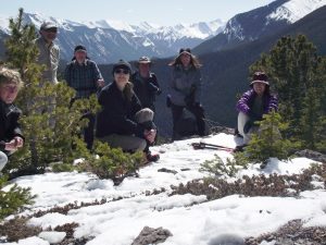
A reminder of every member’s responsibility to keeping yourself and your fellow hikers safe, during this unprecedented time.

Six feet/two metres Social Distancing requirement by AHS and CORE guidelines
Every member in this photo is a minimum of six (6) feet/two (2) metres apart, for social distancing guidelines.
Reminders:
Bring a mask in case you cannot social distance – 6 feet/2 metres, or you need to go into an indoor area and even for use in the parking lot area.
Stay six feet/2 metres for social distancing when hiking and other events. Also, at rest breaks and lunch.
Remember, This Too Shall Pass!!
Alberta Earthquakes: Turtle Mountain (The Frank Slide)
After the Banff (Cascade Mtn) earthquake, I did a little research.
Did you know earthquakes happen frequently in Alberta. Majority are in the Foothills and the Rocky Mountains. These earthquakes occur within the thrust-fault systems that occurred millions of years ago, with the mountain building processes that created the Rocky Mountains. There are clusters of earthquakes detected east of the Rocky Mountain Deformation Belt. The clusters are the Rocky Mountain House Seism Genic Zone – 30kms southwest of Rocky Mountain House, the Brazeau River cluster – 90kms northwest of Rocky Mountain House, the Cardston Earthquake Swarm – 13kms north of Cardston, and the Crooked Lake Sequences – approx. 30kms west of Fox Creek(northeast of Edmonton).
There has been activity in Kananaskis Country, Banff and Jasper but on a more minor scale.

Turtle Mountain, Franks Slide
Turtle Mountain in Crowsnest Pass was caused by an earthquake. The Blackfoot and Kutenai people knew Turtle Mountain as “the mountain that moves.”
The Earthquake occured at 4.10am on April 29, 1903. Seismologists state the primary cause of the Frank slide was the unstable geological structure of Turtle Mountain. A major thrust fault(the Turtle Mtn Thrust Fault) runs thru the mountain. As the thrust fault divides and weakens the layers of rock within the mountain. The erosion by water and ice of sandstone and shale layers on the lower half of the mountain created a significant overhang. Large surface cracks on the top of the mountain allowed water to enter deeper withing the mountain. Water continued to erode the limestone and with the freezing and thawing of water and ice the cracks grew wider, creating more instability. Secondary contributing factor was coal mining at Turtle Mtn. This Slide would have eventually happen even if there was no coal mining activity within the mountain.
Scientists believe there will be another huge rock avalanche that will occur in the future on Turtle Mountain. Turtle Mountain continues to move, a few millimeters per year, to the northeast toward the valley below. On the south and third peaks of the mountain there is a series of large cracks, and this will be the location of the next large rockslide.
Interesting Fact: did you know, all the rock that fell from Turtle Mountain during the Frank slide was approx. one km wide and half a km high and 150 metres thick. It was calculated you can build a wall one metres wide and 6 metres high all the way from Victoria, B.C. to Halifax, Nova Scotia using rock that fell from Turtle Mountain during the slide.
